Enjoy a relaxed afternoon with other Toronto Free-Net members,
sharing sunshine, food, and stories. See old friends and make new ones!
Meet TFN volunteers. Get answers to your questions about TFN or about
the Internet.
Bring the kids! Bring your friends! Bring munchies to share!
At-a-glance:
| What: | Toronto Free-Net 2017 summer picnic
|
| When: | Saturday, 22 Jul 2017, noon - 6 pm (rain or shine)
|
| Where: | picnic area #1, High Park, Toronto
|
| Who: | event open to all TFN members and their guests
|
| Cost: | free!
|
| Questions: | for more info, send email to picnic-info,
|
| as usual, at torfree.net
|
| Directions: | near High Park subway station (details below)
|
| Google Street View:
| looking west from West Road's
divergence from High Park avenue.
(Pop-up navigable view. Big — needs HiSpeed.)
|
|
|
| Map:
| 
|
Details:
- Bring your own food and drinks. If you can, bring some to share.
- Alcohol is disallowed at the picnic site — park rules.
- There is little shade in the middle of the day; remember to bring sun
protection.
- Bring an umbrella in case of rain showers.
Directions by car:
- Drive to High Park avenue & Bloor street.
- Drive south, into the park, along High Park avenue.
- Upon entering the park, High Park avenue becomes two one-way streets
which slowly diverge.
- There are several parking areas (all free of charge) along the
southbound branch of High Park avenue (a.k.a. West Road). Should the
park prove excessively crowded, there is also free of charge street
parking in the side-streets to the north and to the west of the park.
- Continue with the walking instructions.
Directions by TTC:
- Take the subway to High Park station.
- Exit from the station's east end.
- Walk a short distance east to High Park avenue, then south to Bloor,
then cross Bloor and enter High Park.
- Continue with the walking instructions.
TTC ALERT:
Subway closure on our picnic date:
No trains between St George and Broadview, on Bloor line. TTC shuttle
buses will run along that section.
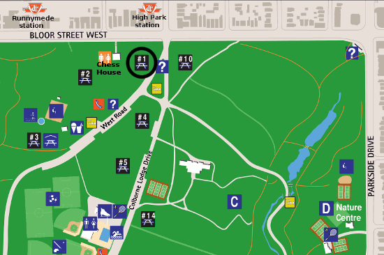
Walking instructions:
- Just 30 metres into the park from Bloor street, High Park avenue
becomes two one-way streets which slowly diverge. On the west
sidewalk, you will see two map billboards. The first one (northmost one)
is exactly at that point of divergence.
- Our picnic table is west and a little south of the first billboard:
walk west-southwest, off the road, into the trees.
- It's about 20 metres (50 paces, a one-minute walk), from the sign
to picnic area #1.
If you reach the brick building (chess house & washrooms), you've
gone too far. We are south and a little east of that.


